Background
GNSS applications in Railways are become more and more frequent. So far the focus has mostly been on non-safety related applications, such as in passenger information systems and for freight logistics, which are also typically not standardised. For these applications the current knowledge of the behaviour of GNSS in the railway environment is largely sufficient, or can be obtained by companies individually.
When moving GNSS application into the domain of safety, such as for train control systems, a much better understanding of GNSS behaviour is needed. This is especially true for the use of GNSS in standardised applications, such as ERTMS, where performance of GNSS receivers has to be harmonised in order to achieve standardised, guaranteed performance and thus interoperability between on-board units of different suppliers.
Objectives
The aim of this project is to fill the gap between ERTMS needs for safety critical applications and EGNSS services, through a characterisation of the railway environment (click on the icon for more details).
Structure
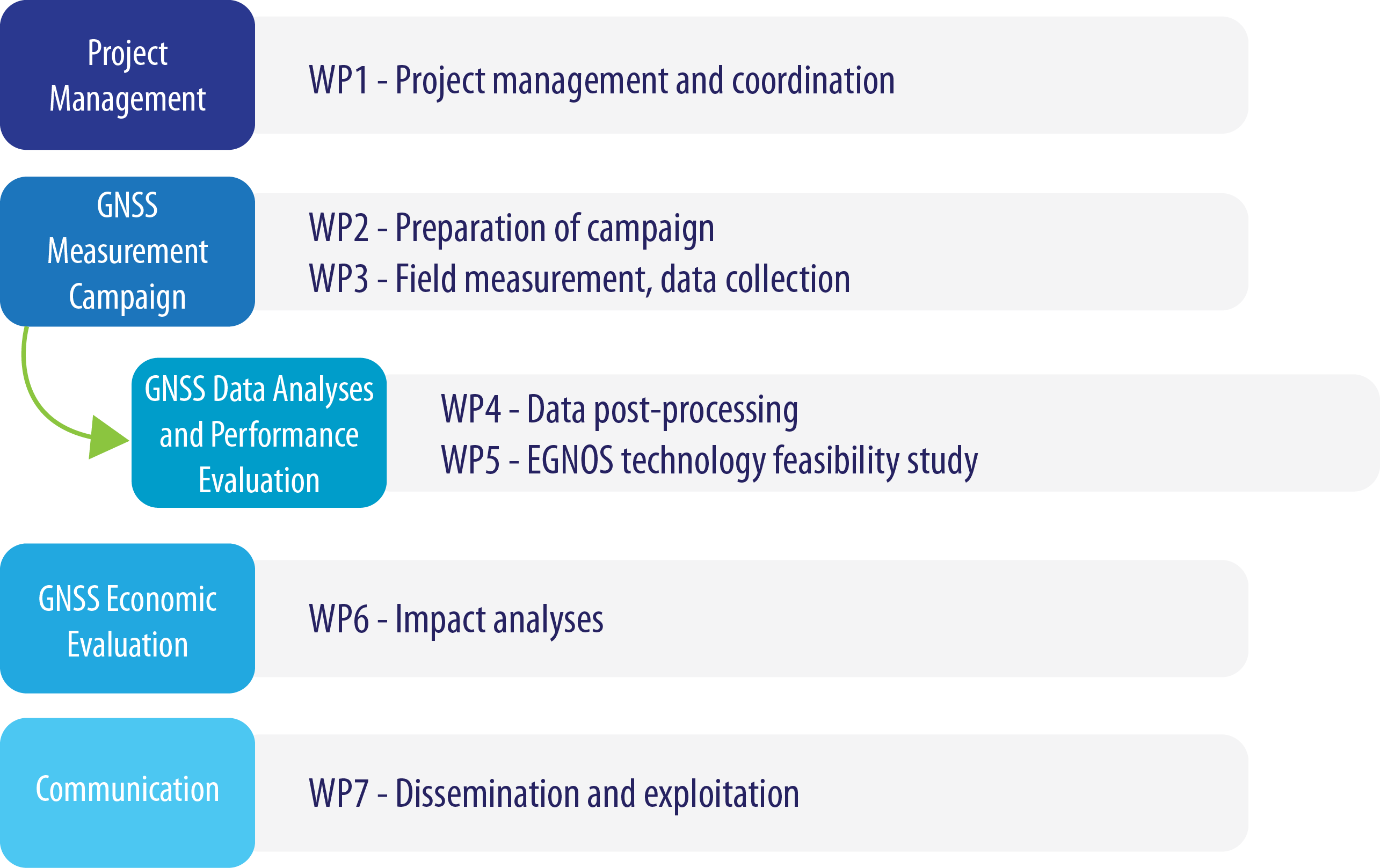
The project has been split into seven work packages, of which five contain the actual work and two the project management and the communication/exploitation (click on the icon for more details).
Objectives
The aim of this project is to fill the gap between ERTMS needs for safety critical applications and EGNSS services, through a characterisation of the railway environment and of GNSS performances assessment in that environment. The application of GNSS in ERTMS shall lead to significant economic benefits through reduction of trackside equipment, reduction of maintenance, increase of availability and performance. This shall also make ERTMS more competitive in comparison with competing systems in the world market, leading to increased business opportunities for the European signalling and space industry.
The STARS project will generate an essential input into a number of research initiatives which pave the way for the safe satellite positioning on railways.
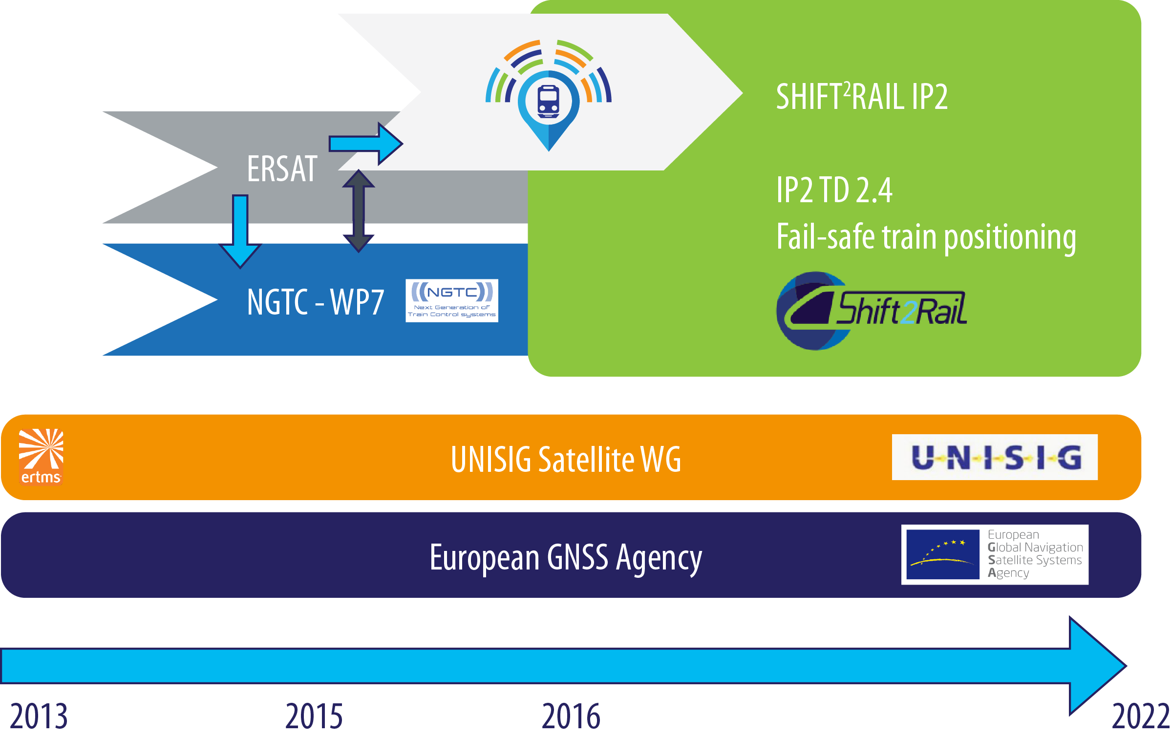
First of all, the STARS will use theoretical work produced within the satellite related work package WP7 in NGTC (EU, FP7 www.ngtc.eu). It will also use data from the ERSAT project, as well as other previous projects (e.g. GRAIL-1, GRAIL-2, LOCOPROL, LOCOLOC, EATS, SATLOC, etc.) from which data is available.
The STARS project will generate a valuable input for Shift2Rail JU (www.shift2rail.org ), where the actual application of GNSS within ERTMS shall be implemented into a demonstrator. Shift2Rail will also utilise STARS data for the other applications of GNSS, e.g. odometry.
The results of the project will form an input to the standardisation of ERTMS, as the application of GNSS in ERTMS will have to be included in the respective standards. ERTMS is an open standard now controlled by the European Railway Agency ERA, and the system is mandated to be used on the European mainline railway network.
Key objectives of the project are:
- To develop a universal approach to predict the achievable GNSS performance in a railway environment, especially for safety critical applications within ERTMS and to determine the necessary evolution of ETCS to include GNSS services;
- To quantify the economic benefits through reduction of cost, which will increased market appeal of ERTMS;
As a result of the project it shall be possible to predict performance of GNSS in the railway environment in regards to accuracy, availability and safety. This shall be possible for specific locations or sections along railway lines, and based on using a receiver compliant with minimum performance standards as defined in the NGTC project. The result will allow us to achieve interoperability between equipment of different suppliers, which is one of the key elements that has led to significant applications of ERTMS also outside Europe.
This shall make it possible to include GNSS into ERTMS, while maintaining both the safety of the system and the interoperability.

Structure
The study logic will be constituted mainly of 3 successive phases: the first one will lead to the elaboration of reference data and characterisation of the railway environment through a measurement campaign, the second one will assess the EGNSS performances achievable in this environment as well as the possible evolutions on EGNSS services and ERTMS/ETCS functions. The third phase will analyse the economic benefit and possible implementation roadmap.
Phase 1: Measurement campaign
- The environment on railway lines (visibility of sky, presence of reflective surfaces such as buildings, electromagnetic interference etc.);
- GNSS signal reception of Galileo, GPS, GLONASS and EGNOS augmentation signals (raw data measurement);
- Receiver behaviour, using aeronautical receivers and possibly other types of receivers for comparison;
The recorded data will be processed and correlated to elaborate a representative reference data set that will be used within the project in order to
- Analyse the performance of different types of receivers in order to define optimal receiver characteristics;
- Predict the EGNSS performances according to the reception conditions across railway network;
Phase 2: EGNSS Performances assessment, safety requirements and impacts on existing systems
The approach proposed for the EGNSS performance assessment will follow the same methodology put in place in EGNOS programme for aeronautical safety of life services. From the characterisation of the railway environment performed in the Phase 1, the error budgets models at user level will be elaborated. These models will be similar than the ones defined in the Minimum Operational Performance Standards (MOPS) for aviation receivers to determine the level of local effects
(i.e. multi-path, masking angle, radio-frequency interferences,…) that a railway receiver should consider.
Finally, predicted EGNSS performances, will be used to determine the necessary evolutions to be implemented on EGNSS services, and receivers as well as the possible impacts on ERTMS/ETCS functions and architecture.
Phase 3: Economic Benefits and roadmap
The evaluation of economic benefits will be performed to
- Develop a business case for the inclusion of EGNSS into the ERTMS standard
- Develop a business case for railway undertakings and infrastructure manages to apply ERTMS with EGNSS in future and possibly also current applications
The project has been split into seven work packages, of which five contain the actual work and two the project management and the communication/exploitation.


